
Antonio Ashi 1,2*; Jihene Nouairi 3; Hany M. Hassan 3; Mounir Ghribi 3; Hossein Bonakdari 4
1, University School for Advanced Studies IUSS Pavia, Palazzo del Broletto, Piazza della Vittoria n.15, 27100 Pavia, Italy
2, Department of Civil Engineering and Architecture, University of Pavia, via A. Ferrata 3, Pavia, 27100, Italy
3, National Institute of Oceanography and Applied Geophysics –OGS, Borgo Grotta Gigante 42/C 34010, Sgonico (TS), Italy
4, Department of Civil Engineering, University of Ottawa, 161 Louis Pasteur Private, Ottawa, ON, K1N 6N5, Canada
E-mail:
antonio.ashi01@universitadipavia.it
Received: 08/03/2026
Acceptance: 12/06/2026
Available Online: 14/06/2026
Published: 01/07/2026

Manuscript link
http://dx.doi.org/10.30493/DAS.2026.011406
Abstract
Urban river basins experience severe impacts from flooding, which ranks among the most common natural hazards across Southern Europe and Northern Italy. Detailed multi-criteria spatial models must be constructed to forecast flood hazard susceptibility (FHS) in these vulnerable zones. Future mitigation strategies can be guided by evaluating vulnerability within these specific watersheds. In this study, nine distinct spatial layers depicting the primary drivers of inundation were formulated for the North Lambro River basin. The evaluated variables comprised Landuse/landcover (LULC), rainfall, elevation, slope, aspect, drainage density, distance to river, stream power index (SPI), and curvature. A comprehensive flood-susceptibility map was produced through the amalgamation of these elements. Geographic Information Systems (GIS) and an Analytical Hierarchy Process (AHP) model facilitated this analytical synthesis. High and very high FHS categories encompass over a quarter of the investigated region. This classification demonstrates a substantial physical exposure to flooding threats. The central and southern sectors contain the highest concentration of these critical zones. Extensive urbanization and abundant impervious surfaces physically define these specific locations. Consequently, the LULC variable emerged as the dominant parameter escalating FHS across the evaluated territory. Local authorities and stakeholders can directly utilize this objective spatial framework to upgrade hazard mitigation protocols. Furthermore, analogous urban watersheds could successfully implement this adaptable methodology.
Keywords: Flood hazard susceptibility, Urban, LULC, Italy
Introduction
Floods are considered one of the most common natural hazards in urbanized areas, especially urban watersheds, which are known for high population density and accelerated urbanization [1-3]. In Europe, flood hazard and associated risks, in terms of frequency and extent, have increased due to the consequences of climate change, extreme rainfall events, changes in exposure (land use/land cover changes), and vulnerability of the systems [4][5]. Thus, it is essential to continue developing accurate scientific tools to assess flood hazards and to develop up-to-date micro-urban flood hazard susceptibility (FHS) maps to support sustainable urban planning and reduce human and economic losses [6], particularly in rapidly urbanizing regions.
The integration of geographic information systems (GIS) and remote sensing data (RS) with statistical models is an effective approach for producing a reliable, spatially explicit FHS map [7]. The Multi-criteria decision making (MCDM) technique is widely utilized in this context for its ability to collect and integrate multiple factors, including environmental, human, and socio-economic factors [8–12]. Moreover, the use of these tools is particularly important in micro-urban watersheds, given the complex spatial interactions among flood-causing factors [13][14] and the high sensitivity of these systems to land-surface modifications.
In Europe, Italy experiences a considerable number of annual flood events, especially in the northern area, which is characterized by high urbanization density as well as increased touristic and economic activity [15], rendering it particularly vulnerable to flood hazards. The Northern Lambro River basin is considered one of the most important watersheds in the Lombardy district. Densely urbanized and industrial areas have been established along the river, leading to accelerated flood events due to urban pressure and the weakening of surface infiltration [16][17], as well as increased surface runoff. Considering the frequent flood events and the availability of spatial data, the Northern Lambro River watershed represents an interesting case study to assess FHS in the region. Additionally, the watershed can be considered a representative case study for the assessment of micro-urban watersheds in Europe that face similar challenges related to urban expansion and climate variability.
Consequently, the current study aims to integrate the Analytical Hierarchy Process (AHP) and GIS to produce an accurate map of FHS in the Northern Lambro River basin. Moreover, this study provides a methodological framework that could be applied in similar micro-urban watersheds across Central Europe to support stakeholders and decision-makers in urban planning and risk management, and to improve adaptation strategies to climate change consequences in urban environments through enhanced spatial decision-support tools.
Materials and Methods
Study area
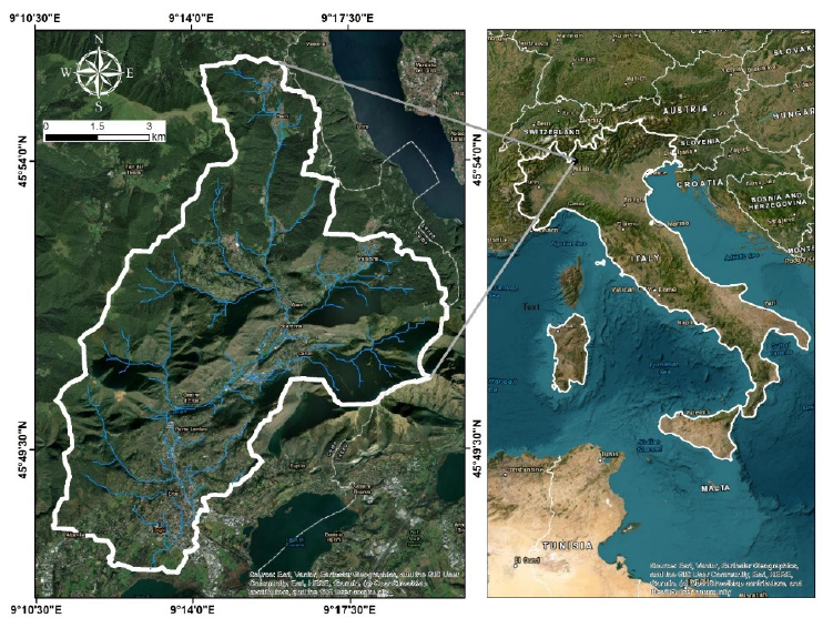
The North Lambro River is located in the northern part of Italy within the Lombardy region, (Figure 1). A distance of nearly 130 km is spanned by the basin and its associated sub-basins. Headwaters are situated in the mountainous terrain surrounding Lake Como, a prominent destination for tourism. The river subsequently travels south through multiple major urban and industrial hubs, including Monza and Milan, prior to its convergence with the Po River, with approximately 81 km² encompassed by the basin. Morphological diversity characterizes the landscape of the river basin. This variety ranges from mountainous headwaters to low-lying plains situated at the river mouth. A peri-urban nature defines the Lambro River with high population density and intensive industrial activity featured throughout the basin, particularly in the lower reaches of the Milan metropolitan area. Some of the highest regional rainfall levels are recorded in the area during the spring and autumn months, often in the form of heavy convective storms [18]. A humid subtropical climate (Cfa) is maintained within the region. Flooding vulnerability is heightened by these specific climatic and urban traits, since surface runoff is accelerated by heavy rainfall in conjunction with urban expansion and land-use alterations. Average discharge remains relatively low; however, significant volume increases occur during rainy periods. Consequently, frequent flooding events are triggered, especially throughout the wet seasons.
Data sources
In the current assessment, several causative factors were selected based on recent literature and expert opinion. These factors are Land-use/landcover (LULC), rainfall, elevation, slope, aspect, drainage density (DD), distance to river, stream power index (SPI) and curvature.
A multi-source dataset was used to create the thematic layer of these factors (Table 1). For the topographical factors, a digital elevation model from the Shuttle Radar Topography Mission (SRTM) Global dataset with a 30 m resolution was used. To explore the LULC units across the study area, data were extracted from Esri and Sentinel-2 Land Cover Explore at a resolution of 10 m. A meteorological dataset, acquired from the Regional Agency for Environmental Protection of Lombardy, was used to create a raster layer of annual average rainfall for the study area. The collected raster data were resampled to 30 m resolution to have homogeneous resolution and conduct fair modeling process.
Considered factors
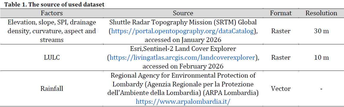
The LULC is a vital factor in reflecting the impact of human activity on terrestrial systems, especially in urban river basins. The terrestrial systems in these areas consist of impermeable surfaces, thus increasing the frequency of flooding. Overall, there are four land use patterns in the study area: urban, agriculture, forest, and bare land (Fig. 2 A). It is worth noting that urban areas constitute a significant portion of the study area.
Rainfall is considered the most important triggering factor for flooding, especially in areas with high rainfall rates. Heavy rainfall incidents result in the saturation of the surface soil layer, thus increasing surface runoff and stimulating drainage. The impact of rainfall on increasing flooding is greater in areas penetrated by urban development. The rainfall rate ranges between 1847 mm in the north and 1243 mm in the south (Fig. 2 B). More flooding events are usually observed in leveled areas with low elevation due to surface runoff accumulation. This situation worsens with increased urbanization in these regions. The elevation in the study area ranges from 255 m to 1443 m (Fig. 3 C).
Slope is considered one of the most influential topographic parameters affecting flood risk. The higher the slope value, the greater the surface runoff and drainage velocity. Conversely, the risk of flooding increases with a lower slope values, especially when combined with impermeable surfaces. Slope values in the study area ranged from gentle to moderate (<9 degrees) in the southern regions to steep or very steep (36 degrees) in northern and central regions (Fig. 2 D). The distance from the river (Fig. 2 E) provides a spatial indicator of the extent to which areas near the river are affected by flooding.
The Stream Power Index (SPI) (Fig. 2 F) is an estimation of surface runoff energy along waterways. The higher the SPI value, the greater the flooding probability, especially in floodplain areas where river channels become meandering and shallow. Drainage density (Fig. 2 G) is calculated as the ratio of the number of streams to the basin area. This characteristic is an important hydrological indicator for assessing surface runoff, which is related to several parameters, such as seepage, soil saturation, and erosion rates.
The aspect factor reflects the impact of precipitation or snowmelt on specific slope faces, which, in turn, affects the flood events (Fig. 2 H). Curvature is considered one of the secondary topographic parameters that trigger flooding, especially in rugged areas (Fig. 2 I). It is considered an estimation of slope distortion, which can influence water accumulation.
The Analytical Hierarchy Process (AHP)
The Analytical Hierarchy Process (AHP) is a robust and straightforward multi-criteria decision-making method. It basically relies on rearranging and organizing influencing factors within a consistent, relative statistical framework to arrive at the best possible decision. This method was developed by Saaty 1980 [19], who demonstrated the possibility of analyzing the target phenomenon into a set of independent influencing factors through pairwise comparisons. This method has demonstrated effectiveness and accuracy across numerous studies, particularly in spatial decision-making.
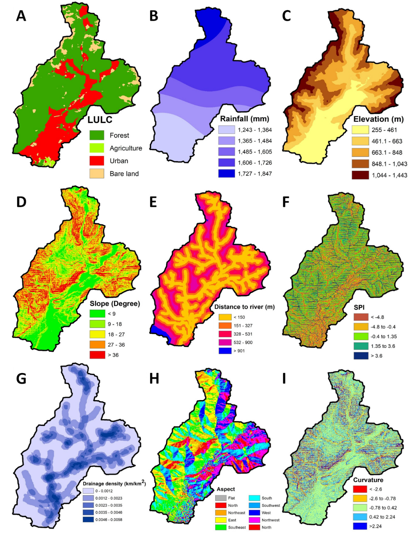
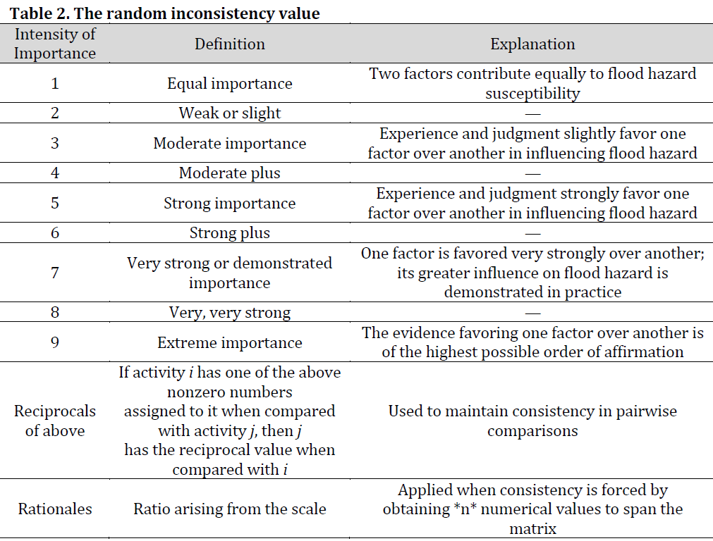
The statistical basis of this method consists of a set of pairwise comparisons on a scale of 1 to 9, according to the degree of importance of each factor (Table 2). Then, the consistency ratio (CR) is calculated to assess the reliability of the results before they are used in the final analysis (Table 3).

The eigenvector (Vp) and the weighting coefficient (Cp) were calculated:
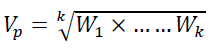
where k is the number of factors and W is the rating of each factor
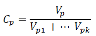
The Eigenvalue (λmax), consistency index (CI), and consistency ratio (CR) were then computed:
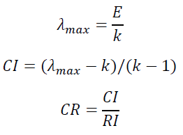
where RI is the random index.
The CR value should be less than 0.1 (i.e., 10%) [19], otherwise, the judgments are untrustworthy. In this study, a CR value of 0.081 was obtained (which is less than the preassigned 0.1 threshold); hence, the judgments are acceptable.
Results and Discussion
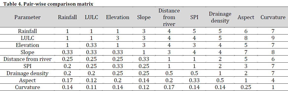
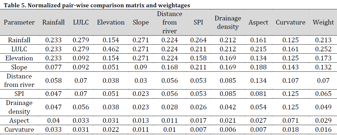
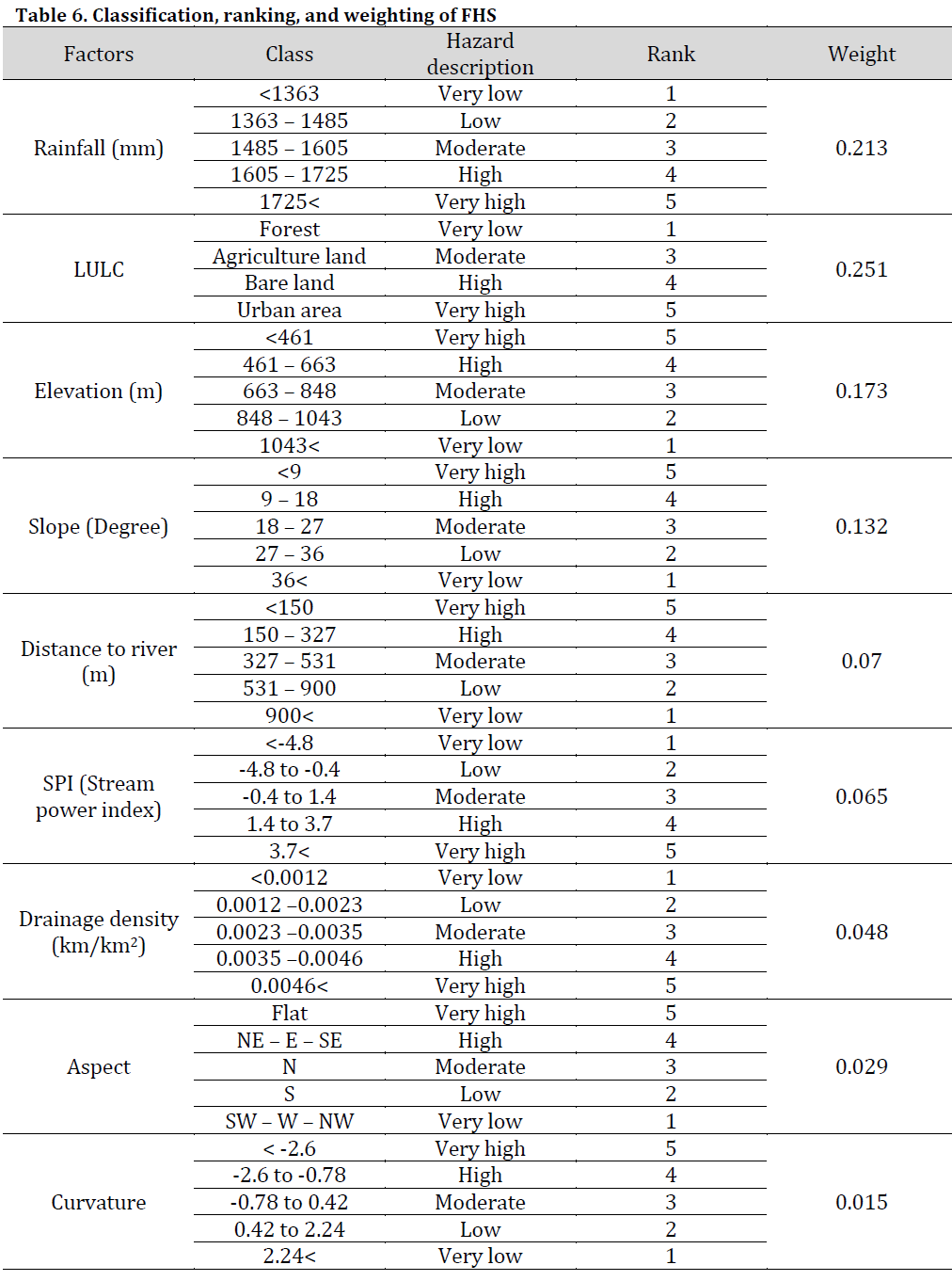
This research aimed to produce an FHS-index map of the river basin using the integration of AHP and geospatial tools. Using a pairwise comparison matrix and the resulting weights in the final weight matrix (Tables 4, 5, and 6), an FHS index was developed according to the following mathematical equation.
FHS = (LULC × 0.251) + (Rainfall × 0.213) + (Elevation × 0.173) + (Slope × 0.132) + (Distance to river × 0.07) + (SPI × 0.065) + (Drainage density × 0.048) + (Aspect × 0.029) + (Curvature × 0.015)
Using FHS equation, an F-index map of the basin was produced, showing the spatial distribution of FHS classified into very high, high, moderate, low, and very low levels (Fig. 3). Despite almost half the studied area (40.04 Km2, 49%) were classified at low to very-low flood hazard susceptibility, 27% of the total area were at high to very-high flood hazard susceptibility. High and very high-risk values were concentrated in the central and southern regions of the study area. These regions are characterized by the spatial integration of low-slope (Fig. 2 D) and Low elevations, with spatial proximity of mountain masses and hills (Fig. 2 C), as well as urban sprawl (Fig. 2 A) and accelerated human activity. This spatial combination of the aforementioned factors contributes to increased surface runoff accumulation, especially near waterways. Furthermore, flood risk increases with impermeable urban surfaces, which reduce the soil’s hydrological permeability. The limited absorption of surface runoff, particularly in the cities of Canzo, Erba, and Asso, which represent the most important urban centers in the study basin, is a significant concern.
The inefficiency of drainage systems, especially during and after heavy rainstorms, increases the likelihood of flooding. Therefore, it can be confirmed that the spatial interplay between natural and human factors, particularly the presence of urban areas on low-lying slopes near the floodplain, has amplified the flood risk. Moreover, rapid land-use change within the study basin exacerbates the negative impacts of flood risk.
The results showed that LULC was the most influential factor in FHS, with an importance level of 25%, followed by rainfall, elevation, and slope at 21%, 17%, and 13%, respectively (Fig. 3 A). This means that these four factors accounted for over 70% of the impact, while the remaining five factors had a secondary influence on flood risk. These findings are consistent with the spatial characteristics of urban river basins in Europe, particularly those near large cities like Milan, which acts as a catalyst for accelerating spatial changes in the geographical features of its surrounding land. Recent studies in Milan indicate that urban expansion and increased impermeable surfaces have led to a significant increase in surface runoff and flooding frequency [20]. Research has also shown that the occupation of floodplains and the modification of waterways have directly contributed to increased flood risk [21]. These results underscore that land-use management and sustainable urban planning are crucial factors in mitigating flood risks in northern Italy [22][23].
To further clarify the spatial distribution of flood risk in urban areas, the urban area in the study region was extracted from the resulting flood risk layer (Fig. 3 B). In this regard, the five flood risk scores were reclassified within urban areas only, aiming to rank urban centers according to their flood risk. The results indicate that urban centers located in the central parts of the study basin (such as Canzo, Scarenna, and Asso) as well as those in the northern parts (Magreglio and Barni) are classified as cities with very high flood risk. This can be explained by the high concentration of urban areas with low slope values and their proximity to the drainage network. In contrast, urban centers in the Southern parts of the study basin (such as Buccinigo) were classified as having low risk due to the relatively higher slope values, dense forest cover (to the north), and highly permeable surface hill formations. Thus, it can be confirmed that the degree of flood risk in urban areas is determined according to spatial characteristics related to topography, rainfall, and vegetation density, which is consistent with previous assessments [24][25].
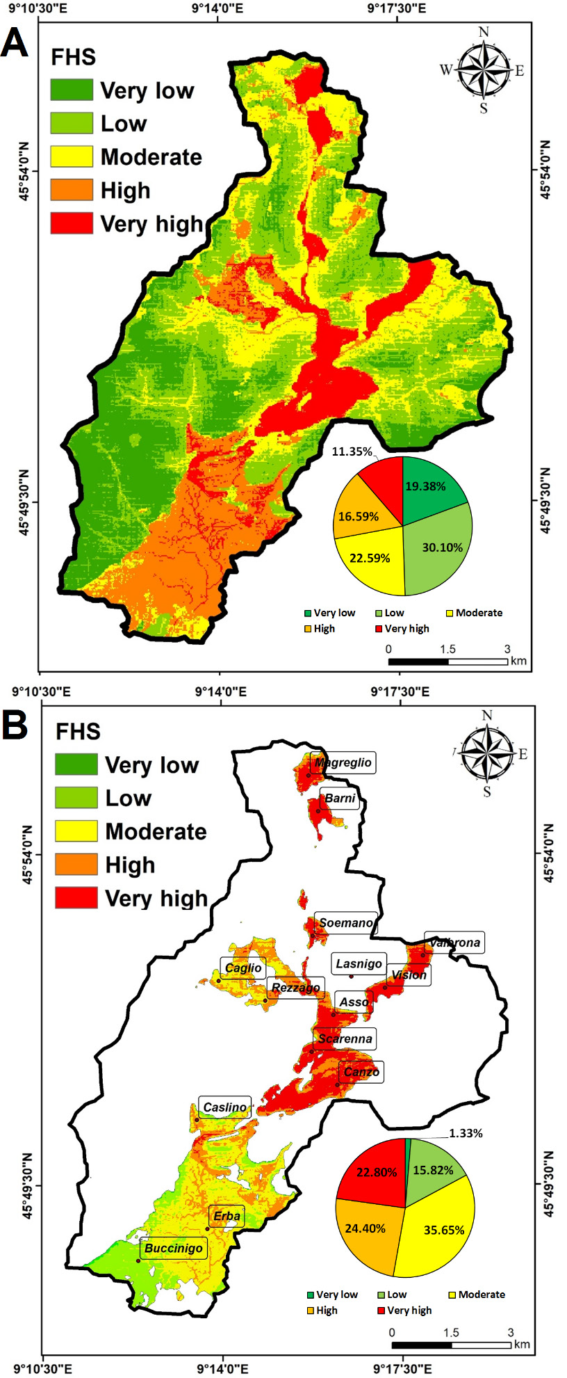
It is worth noting that almost have the urbanized area (47.2%) is categorized under high and very high flood risk class (Fig. 3 B). This observation necessitates drastic and effective measures in order to mitigate flood risk. These actions include the implementation of nature-based solutions (NbS), such as permeable pavements, green roofs, and rain gardens, especially in high-density impervious zones to enhance surface water infiltration and reduce runoff peaks [26]. Additionally, the drainage infrastructure in central areas should be updated to further mitigate flood risk in old towns and traditional neighborhoods.
The current findings highlight the central highly urbanized area of north Lambro River basin as the most susceptible to flooding hazard. Such observation refers to the numerous dire urban and environmental consequences that might occur as a result of flood events. Soil erosion, water pollution, disruptions to ecosystems, and adverse impacts on infrastructure and residential areas are among the most prominent consequences of flood risk. Therefore, there is a need to develop sustainable spatial flood risk management strategies for the study basin that address large-scale urban flooding, which may support decision-makers and stakeholders in Northern Italy.
Conclusions
Unforeseen flooding can result in natural disaster requiring assessment through flood susceptibility mapping, particularly in urban river basins, where the primary objective is to conduct multi-criteria assisted flood risk mapping. In this study, flood hazard susceptibility in the Northern Lambro River basin was mapped using a GIS environment and utilizing nine factors. The study area was classified into five flood hazard susceptibility levels named: very high, high, moderate, low, very low. The flooded area per FHS level was computed accordingly: 11.35%, 16.58%, 22.58%, 30.09%, and 19.37%, respectively. These results make a reasonable contribution to urban planners and decision-makers, enabling them to design sustainable infrastructure and mitigate flood hazards in northern Italy.
Conflict of interest statement
The authors declared no conflict of interest.
Funding statement
The authors declared that no funding was received in relation to this manuscript.
Data availability statement
The authors confirm that all data sources utilized in this study are explicitly cited within the manuscript. The datasets generated and analyzed during the current study are available from the corresponding author upon reasonable request.
References
- Zhu Q, Klaar M, Willis T, Holden J. A Quantitative Review of Natural Flood Management Research. Wiley Interdiscip. Rev. Water. 2024;12(1):e1765. DOI
- Hansamali U, Makumbura RK, Rathnayake U, Azamathulla HM, Muttil N. Leaky Dams as Nature-Based Solutions in Flood Management Part I: Introduction and Comparative Efficacy with Conventional Flood Control Infrastructure. Hydrology. 2025;12(4):95. DOI
- Park K, Choi SH. Analysis of urban flood risk for the implementation of sustainable land use measures. Clim. Serv. 2025;38:100568. DOI
- Shamsudduha M. Redefining flood hazard and addressing emerging risks in an era of extremes. npj Nat. Hazards. 2025;2(1):29. DOI
- Santos E. Nature-Based Solutions for Water Management in Europe: What Works, What Does Not, and What’s Next?. Water. 2025;17(15):2193. DOI
- Albano R, Adamowski J. Use of digital elevation models for flood susceptibility assessment via a hydrogeomorphic approach: A case study of the Basento River in Italy. Nat. Hazard. 2025;121(8):9021-42. DOI
- Vojtek M, Moradi S, Petroselli A, Vojteková J. Comparative analysis of hydraulic and GIS-based Height Above the Nearest Drainage model for fluvial flood hazard mapping: a case of the Gidra River, Slovakia. Stochastic Environ. Res. Risk Assess. 2025;39(6):2657-75. DOI
- Mascheri G, Chieffo N, Pugliese F, Pinto C, Lourenço PB. A GIS–MCDM–Based Framework for Flood Risk Scenario in Central Lisbon. Int. J. Archit. Heritage 2026:1-21. DOI
- Maru DR, Kumar V, Sharma KV, Pham QB, Patel A. Integrating GIS, MCDM, and Spatial Analysis for Comprehensive Flood Risk Assessment and Mapping in Uttarakhand, India. Geol. J. 2025;60(9):2263-80. DOI
- Idrizi B, Nimani A, Pashova L. Identification of Potential Flood-Prone Areas in the Republic of Kosovo Using GIS-Based Multi-Criteria Decision-Making and the Analytical Hierarchy Process. Sustainability. 2025;18(1):359. DOI
- Mazarakis V, Tsanakas K, Greenbaum N, Batzakis D, Sorrentino A, Tsodoulos I, Valkanou K, Karymbalis E. Flood-Hazard Assessment in the Messapios River Catchment (Central Evia Island, Greece) by Integrating GIS-Based Multi-Criteria Decision Analysis and Analytic Hierarchy Process. Land. 2025;14(3):658. DOI
- Nivolianitou Z, Synodinou B, Manca D. Flood disaster management with the use of AHP. Int. J. Multicrit. Decis. Mak. 2015;5(1/2):152. DOI
- Taoukidou N, Karpouzos D, Georgiou P. Flood Hazard Assessment Through AHP, Fuzzy AHP, and Frequency Ratio Methods: A Comparative Analysis. Water. 2025;17(14):2155. DOI
- Kasahun M, Diriba D, Lemma T, Karuppannan S, Kanko N. Flood vulnerability and risk mapping in Arba minch city using remote sensing, GIS and AHP. Sci. Afr. 2025;30:e02976. DOI
- Lucaora T, Annis A, Nardi F, Rulli MC, Chiarelli DD. Distributed hydrodynamic modelling for assessing flood impacts on crops: Assessing flood-resilient crop management in a coastal basin of central Italy. Agric. Water Manag. 2025;309:109352. DOI
- Cazzaniga G, De Michele C, D’Amico M, Deidda C, Ghezzi A, Nebuloni R. Hydrological response of a peri-urban catchment exploiting conventional and unconventional rainfall observations: The case study of Lambro catchment. Hydrol. Earth Syst. Sci. Discuss. 2021;2021:1-26. DOI
- Vitale C. Understanding the shift toward a risk-based approach in flood risk management, a comparative case study of three Italian rivers. Environ. Sci. Policy. 2023;146:13-23. DOI
- Ceppi A, Gambini E, Lombardi G, Ravazzani G, Mancini M. SOL40: Forty Years of Simulations under Climate and Land Use Change. Water. 2022;14(6):837. DOI
- Saaty TL. The analytic hierarchy process (AHP). J. Oper. Res. Soc. 1980;41(11):1073-6.
- Vitale C, Meijerink S, Moccia FD, Ache P. Urban flood resilience, a discursive-institutional analysis of planning practices in the Metropolitan City of Milan. Land Use Policy. 2020;95:104575. DOI
- Raimondi F, Marchioni ML, Dresti C, Kian D, Mambretti S, Becciu G. Urban Flood Risk Management: Impact of Combined Strategies. Int. J. Environ. Impacts Manag. Mitig. Recovery. 2021;4(3):219-30. DOI
- Mannucci S, Kwakkel JH, Morganti M, Ferrero M. From past to future: understanding urban development in flood-prone coastal Rome. J. Urban Des. 2024;30(3):315-46. DOI
- Santini L, Frosini G, Fabrizio C. Urban Regeneration for the Resilient City: Implementation of Sustainable Urban Drainage Solutions in Pisa’s High Flash Flood Risk Areas. Environ. Sci. Sustain. Dev. 2025;10(1):13-23. DOI
- Zhang J, Wang R, Li X, Li Z, Wang Y, Zhang X. A study on the effect of spatially variation rainfall on urban flooding. Geomat. Nat. Hazards Risk. 2025;16(1):2548912. DOI
- Li Y, Osei FB, Dai S, Hu T, Stein A. Identifying landscape patterns at different scales as driving factors for urban flooding. Ecol. Indic. 2025;176:113614. DOI
- Ismaeel WSE, Mustafa NA. Practical Steps for Urban Flood Risk Mitigation Using Nature-Based Solutions—A Case Study in New Cairo, Egypt. Land. 2025;14(3):586. DOI
Cite this article:
Ashi A, Nouairi J, Hassan HM, Ghribi M, Bonakdari H. A multi-criteria spatial model for flood hazard susceptibility in the North Lambro River basin, Italy. DYSONA-Applied Science. 2026;7(2):290–300. doi: 10.30493/das.2026.011406